Hurricane Gabrielle (2025): Overview
#SuperTyphoonRagasa has made landfall in Babayun Islands, Philippines with winds of 165-170mph, a pressure of 910mbars and a movement of west at 14mph. Extremely gusty winds and extremely heavy rainfall will continue through tonight #BREAKING #wxtwitter #tropicswx #Tropicalupdate pic.twitter.com/Rv4OfrVWwp
— severewxguy (@weathermandan10) September 22, 2025
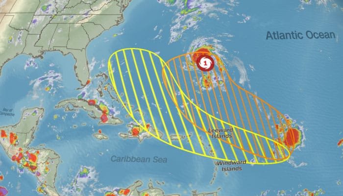
Hurricane Gabrielle is the second hurricane of the 2025 Atlantic season. It began as a tropical storm on September 17 in the central Atlantic, about 1,000 miles east of the Northern Leeward Islands. Early winds were modest, around 45 to 50 miles per hour. Several environmental factors, including wind shear, dry air, and Saharan dust, slowed its initial growth by limiting strong thunderstorms and organization.
Strengthening & Structure

Despite challenges, Gabrielle strengthened and became a Category 1 hurricane by September 21, with sustained winds near 75 miles per hour and a central pressure around 1,004 millibars. The storm has become more organized but remains somewhat uneven, with strongest winds and rain on the eastern and northeastern sides. Tropical-storm-force winds extend roughly 150 miles from the center, varying by direction.
Current Location & Track

Gabrielle is about 320 miles southeast of Bermuda, moving north-northwest at around 10 miles per hour. It is expected to continue this path, turning north then northeast in the coming days. The hurricane is forecast to pass east of Bermuda, avoiding direct landfall, but still poses risks to the island and coastal areas further north.
Forecasted Intensity Changes
Conditions favor further strengthening soon. If wind shear lessens and sea temperatures stay warm, Gabrielle could become a major hurricane (Category 3 or higher). It will likely weaken later as it moves into cooler waters and stronger upper-level winds disrupt its structure.
Potential Impacts
Even without landfall, Gabrielle will cause large ocean swells and high surf along the U.S. East Coast, Bermuda, and parts of Atlantic Canada. These conditions may create dangerous rip currents and beach erosion, especially north of North Carolina. Coastal areas should watch for minor flooding from onshore winds and high tides. Rainfall in Bermuda is expected to be scattered due to the storm’s uneven structure.
Uncertainties & Track Considerations
The storm’s future depends on how quickly wind shear eases and how much dry air and Saharan dust remain. The subtropical ridge and mid-latitude troughs will influence Gabrielle’s path and timing of its north and northeast turns. Small changes in the track could affect which coastal areas experience stronger winds or rougher seas.
Probabilities & Risks
BREAKING: Gabrielle has become the 2nd Hurricane of the season in the Atlantic Ocean, and will just past East of Bermuda tomorrow. pic.twitter.com/fny6DSA33m
— Max Velocity (@MaxVelocityWX) September 21, 2025
There is a 20 to 25 percent chance Bermuda might see tropical-storm-force winds. The U.S. mainland is not expected to have direct impacts at this time.
Seasonal Context
Gabrielle breaks a nearly three-week lull in the Atlantic hurricane season. It shows that storms can still develop and intensify even under less favorable conditions. The hurricane reminds us that storms far at sea can still affect coastal and marine environments.
What to Watch
Super Typhoon #RAGASA has made landfall in Babayun Islands, Philippines, with winds of 175-180mph.
Destructive winds will continue to batter the Batanes and Babayun Islands tonight. pic.twitter.com/lPf0l4EUS0
— Weather Track US (@weathertrackus) September 22, 2025
Updates from official sources regarding watches and warnings will be important, especially for Bermuda and maritime activities. Data from hurricane hunter flights will improve strength and structure forecasts. Coastal residents and marine operators should remain alert to surf conditions, rip currents, and beach safety, which can worsen well before the storm’s center arrives.